
![]()

| 22 Mar 1819 | CLARK created from CRAWFORD. (Ill. Laws 1819, pp. 166-167) |
| 31 Jan 1821 | CLARK lost to creation of PIKE. (Ill. Laws 1820-1821, p. 59) |
| 14 Feb 1821 | ,CLARK lost to creation of FAYETTE. (Ill. Laws 1820-1821, pp.164-167) |
| 23 Dec 1822 | CLARK gained small area from CRAWFORD. (Ill. Laws 1822-1823, p. 79) |
| 03 Jan 1823 | CLARK lost to creation of EDGAR and to creation of Non-County Area 4. (History of Edgar, 514-515; Ill. Laws 1822-1823, pp. 74-75) |
| 18 Jan 1826 | CLARK lost to creation of VERMILION and lost to Non-County Area 4. (Ill. Laws 1826, pp. 50-53) |
| 25 Dec 1830 | CLARK lost to creation of COLES. (Ill. Laws 1830-1831, pp. 59-61) |
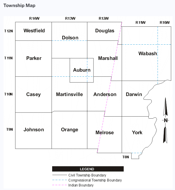
| Westfield | Dolson | Douglas | Wabash |
| Parker | Auburn | Marshall | |
| Cumberland | Martinsville | Anderson | Darwin |
| Johnson | Orange | Melrose | York |
Agricultural Society - 1869
Baker Store Burns - Clark County Herald - 1883
Board of Supervisors -
1868 - 1873 - 1876 - 1882 - 1886 - 1888 - 1892
George Burkett Goes Free - 1908
City Clerk's Report, Marshall - 1882
Clark County Democrat extractions - 1897 - 1898 1918
Clark county officers - 1894 - 1885
Craig - Trimble Wedding - 1904
Early Recollections of Clark County
Courthouse Location Discussion - 1849
First Grand Jury 1820
Flag of the Union Newspaper 1861-1864
Grand Jurors 1868 - 1876 - 1889
Memorial Day Program including the GAR - 1908
Old Settlers Meeting 1877
Old Settlers Meeting 1894
Old Settlers Meeting 1895
Old Settlers Meeting 1911
Old York Destruction 1907
Old York Long Ago Days
Petit Jurors 1882 and 1909
Petition for Dr. Gulley - 1899
Pinnell Family Reunion - 1921
Railroad Meeting 1849
Redman-Bennett Reunion - 800 attended - 1921 announcement and reunion
Republican Club - 1860
Willard 50th Anniversary about 1937
All Townships Elections 1882 1894 and 1897
Crawford County News - Hutsonville - West York - news before 1939
West York Report 1876
West York Notes -1895
West York - Jan Feb Mar 1907
Unclaimed Letters at the Post Office - 1877
Taken to Asylum
Melrose In A Stir, Clark County Herald, 18 Jan 1893
"From Melrose" News Articles 1877 various to 1907
Handy-Hull Wedding 1908
Melrose Township Elections 1893 various to 1909
Melrose Considered for Railroad Route - 1882
Melrose Grange - 1876
Hall, James, 100 years old in 1876
Melrose Homecoming 1936
Orange Township
Parker Township
Wabash Township
Westfield Township
York Township
For corrections or additions, please contact me: Jamie Poorman, County Coordinator